
| Weather Data Acquacalda Lucca | |||
|---|---|---|---|
| LAST READING AT TIME: 15:30 DATE: April 02 2026, time of next update: 16:00 | |||
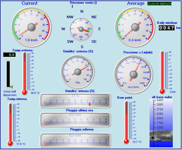
| Current Weather | Dry | Current Temperature | 18.7°C (65.7°F) (Heat Index 18.7°C ), Apparent temp 14.4°C , Apparent temp solar 19.0°C |
| Maximum Temperature (since 0100 hour ) | 19.7°C at: 12:10 | Minimum Temperature (since 0100 hour ) | 8.4°C at: 07:40 |
| Average windspeed (ten minute) | 19.4 kmh (10.5 kts) | Wind Direction (ten minute) | NNE (17°) |
| Windchill Temperature | 18.7°C | Maximum Gust (last hour) | 38.2 kmh (20.6 kts) at: 14:38 |
| Maximum Gust (since 0100 hour ) | 38.9 kmh (21.0 kts) at: 14:38 | Maximum 1 minute average (since 0100 hour ) | 32.8 kmh (17.7 kts) at: 15:00 |
| Rainfall (last hour) | 0.0 mm | Rainfall (since 0100 hour ) | 0.0 mm (0.00 in.)--- |
| Rainfall This month | 0.0 mm (0.00 in.) | Rainfall To date this year | 0.0 mm (0.00 in.) |
| Maximum rain per minute (last hour) | 0.0 mm/min | Maximum rain per hour (last 6 hours) | 0.0 mm/hour |
| Yesterdays rainfall | 0.0 mm | DewPoint | 2.1°C (Wet Bulb :11.1°C ) |
| Humidity | 33 %, Humidex 17.1°C | Barometer corrected to msl | 1001.3 hPa |
| Pressure change | -0.1 hPa (last hour) | Trend (last hour) | STEADY |
| Pressure change (last 12 hours) | -2.4 hPa | Pressure change (last 6 hours) | -1.2 hPa |
| Current Indoor Temp. 18.8°C | |||
| Current Indoor Hum. 37% | |||
| Current Solar 408 W/m˛ | |||
| Maximum solar (since 0100 hour ) | 698 W/m˛ | Minimum solar (since 0100 hour ) | 0 W/m˛ |
| Current 00:11 hours of sunshine today, current sky: Overcast and gloomy | |||
| Sunshine hours for the year: | 20:15 hrs | Sunshine hours for the month: | 00:25 hrs |
| Current evapotranspiration rate 3.6 mm per day. Yesterday's reading 4.1 | |||
| Lightning counts 0 since noon | |||
| Time of last strike | 07:26:30 28/03/2026 | Counts in the last 30 minutes | 0 |


Use the RELOAD facility on your browser to retrieve the latest data.